Nature study finds Google’s WeatherNext AI gains at least a day in cyclone forecasting
The research tested the model on tropical cyclones from 2023 to 2025, while Google has made its code and weights freely available
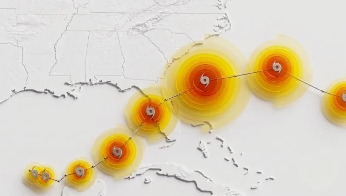
WeatherNext Cyclones forecasts tropical cyclone tracks, intensity and wind structure using a global AI weather model
A Nature study has found that Google’s WeatherNext Cyclones AI model achieved an average lead-time advantage of at least one day when forecasting tropical cyclone tracks, intensity and wind structure.
The study, published as an accelerated article preview on August 6, evaluated tropical cyclones from 2023 to 2025. At five days out, WeatherNext Cyclones recorded an average track error of 230 km, compared with 370 km for the European Centre for Medium-Range Weather Forecasts’ ENS and 335 km for Google’s GenCast. The researchers calculate that this represents just over 30 hours of additional lead time at that accuracy against ENS and approximately 24 hours against GenCast.
Sharing the study on LinkedIn, Yossi Matias, Vice President at Google and Head of Google Research, wrote: “On average, the model extends accurate forecasting by an additional day - it can predict three days ahead with the accuracy previous models achieved with only two. This scale of improvement corresponds roughly to a decade’s worth of meteorological progress historically.”
The research is led by Ferran Alet, Tom R. Andersson, Ilan Price and Stratis Markou. Its authors represent Google DeepMind, Google Research, the University of Waterloo, the U.S. National Hurricane Center, the Cooperative Institute for Research in the Atmosphere at Colorado State University and the UK Met Office.
Training separates development from the test years
WeatherNext Cyclones is a probabilistic global AI weather model designed to forecast a cyclone’s track, intensity and wind structure while also modeling wider atmospheric conditions. It produces ensembles of possible global weather and cyclone scenarios extending 15 days into the future.
The system was trained on nearly 20 terabytes of global atmospheric data and the International Best Track Archive for Climate Stewardship, known as IBTrACS. The database covers nearly 5,000 observed tropical cyclones spanning 45 years, including information on their tracks, maximum wind speeds and wind radii.
During development, the researchers trained the AI model on data from 1979 to 2021 and used 2022 for validation. Its forecasting protocol was then frozen before evaluation. For each test year, the model was retrained using data available through the end of the previous calendar year.
Cyclone predictions were tested globally for 2023 and 2024. The 2025 evaluation covered the North Atlantic and East Pacific basins, where a version of the model ran operationally. Comparisons were conducted on a homogeneous basis, meaning a forecast was included only when every model being assessed had produced a prediction and the cyclone remained active at that lead time.
WeatherNext Cyclones depends on operational atmospheric analysis data. The study states that its forecasts arrive approximately 6.5 hours after the relevant synoptic time. To reflect that delay, paired evaluations used forecasts initialized six hours earlier and corrected them with the latest real-time cyclone observations.
AI intensity results challenge the resolution trade-off
Against NOAA’s Hurricane Analysis and Forecast System, a specialized regional model, WeatherNext Cyclones produced lower average intensity errors across every forecast horizon tested. The difference was statistically significant between 0.5 and 3.25 days, with the three-day forecast recording an average intensity error 3.75 knots lower than HAFS.
Its probabilistic intensity forecasts also reduced the Continuous Ranked Probability Score by more than 50% at many lead times when compared with ENS and a debiased version of GenCast. For the extent of 34-knot winds, the AI model recorded lower errors than both ENS and HAFS.
Those results were produced using atmospheric inputs with a resolution of approximately 28 km by 28 km. Google describes this as 100 times coarser than the inputs used by traditional specialized intensity models. The researchers say the finding indicates that high resolution is not a strict requirement for accurate intensity forecasting, although they acknowledge that it remains unclear how the model extracts this information from coarser data.
WeatherNext Cyclones uses Functional Generative Networks to scale its ensembles from the conventional 50 members to as many as 1,000. In the study’s economic-value assessment, a 1,000-member ensemble at seven days provided more value at a low cost-to-loss ratio than a 50-member ensemble at five days.
The researchers also simulated adding WeatherNext Cyclones to modified versions of two National Hurricane Center consensus ensembles. Track accuracy improved by between 18% and 38%, with an average improvement of 28%. Intensity accuracy increased by between 5% and 14%, averaging 6%. The weights used in those combinations were optimized on 2022 cyclone data from the North Atlantic and East Pacific.
Experimental WeatherNext Cyclones forecasts were supplied to the National Hurricane Center during the 2025 Atlantic hurricane season. Google says the AI model contributed to the center’s advance forecast of Hurricane Melissa’s rapid intensification and landfall in Jamaica.
Open release comes with unresolved limits
The Nature study is an accepted, peer-reviewed paper, but the version published on August 6 remains unedited. Nature states that it will undergo further editing and warns that the manuscript may contain errors that affect its content.
Other limitations are set out in the research. Wind radii derived from IBTrACS are approximate, and more precise assessments of winds at individual locations are left for future work. The researchers also identify cyclone-related precipitation, storm surge and precise wind gusts as areas the model does not yet address.
Google has released the code and model weights for WeatherNext Cyclones and WeatherNext 2. The release also includes WeatherNext 2-mini, a compact version that can run on a single TPU through a free public Colab notebook.
Forecasts are available to explore through Google’s Weather Lab, which displays cyclone tracks alongside predictions for temperature, precipitation and wind speed. Google states that official forecasts and warnings should continue to be obtained from local meteorological agencies and national weather services.